


We Use Cookies
This website uses cookies to ensure you get the best experience on our website.
Garner valuable insights from images, videos, sensors and geospatial data to discover endless possibilities using Artificial Intelligence and Machine Learning.
Meticulously label/annotate different types and size of images with precise capturing tools to make it recognizable for machines.
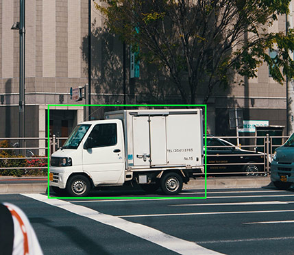
Annotate 2D and 3D patterns in running images and account for all moving objects in a video frame to train a wide range of ML models.
Bring together inputs from multiple sensors and disparate sources such as Radars, LiDARs, and Cameras to develop a single model of the surroundings of an object/vehicle.
Power autonomous vehicles, drones, and other computer vision applications to enable accurate interpretation of images and video using high-quality datasets.
Garner valuable insights from images, videos, sensors and geospatial data to discover endless possibilities using Artificial Intelligence and Machine Learning.
NextWealth’s NLP capabilities in audio and text can help enterprises in query/content understanding as well as improve both user experience and insight discovery.
Make texts comprehensible to machines by identifying important keywords, classifying, and tagging texts within the predetermined set of categories to enable virtual assistants/chatbots etc to easily understand the texts multiple dialects and languages.
ML models require annotated audio to make sound more comprehensible for chatbots or virtual assistant devices. By providing audio annotation service to recorded sounds or speech, NextWealth adds metadata to make the human – machine interaction more meaningful.
NextWealth’s NLP capabilities in audio and text can help enterprises in query/content understanding as well as improve both user experience and insight discovery.
AI has helped the eCommerce industry maintain its dynamic operations to ensure a seamless customer experience. Craft smart and digitally focussed customer experiences that demand quality and are strategically lean towards transformational growth.
Identify and replace incomplete, inaccurate, irrelevant, and complex data and records.
AI has helped the eCommerce industry maintain its dynamic operations to ensure a seamless customer experience. Craft smart and digitally focussed customer experiences that demand quality and are strategically lean towards transformational growth.
BPO Outsourcing offers businesses the flexibility to scale their operations up or down, accelerate growth and improve the bottom line while keeping customers satisfied.
Digital CX involves handling the interactions of customers with businesses across their physical and digital touchpoints delivering customer experience that retains the customer’s loyalty and trust in the brand.
Back-office services refer to those non-core activities ranging from document verification and data entry to financial and accounting processes, medical coding and billing to identity verification services to achieve greater accuracy, agility, and responsiveness.
BPO Outsourcing offers businesses the flexibility to scale their operations up or down, accelerate growth and improve the bottom line while keeping customers satisfied.
BPO Outsourcing offers businesses the flexibility to scale their operations up or down, accelerate growth and improve the bottom line while keeping customers satisfied.
BPO Outsourcing offers businesses the flexibility to scale their operations up or down, accelerate growth and improve the bottom line while keeping customers satisfied.
Garner valuable insights from images, videos, sensors and geospatial data to discover endless possibilities using Artificial Intelligence and Machine Learning.
Meticulously label/annotate different types and size of images with precise capturing tools to make it recognizable for machines.
Annotate 2D and 3D patterns in running images and account for all moving objects in a video frame to train a wide range of ML models.
Bring together inputs from multiple sensors and disparate sources such as Radars, LiDARs, and Cameras to develop a single model of the surroundings of an object/vehicle.
Power autonomous vehicles, drones, and other computer vision applications to enable accurate interpretation of images and video using high-quality datasets.
Garner valuable insights from images, videos, sensors and geospatial data to discover endless possibilities using Artificial Intelligence and Machine Learning.
NextWealth’s NLP capabilities in audio and text can help enterprises in query/content understanding as well as improve both user experience and insight discovery.
Make texts comprehensible to machines by identifying important keywords, classifying, and tagging texts within the predetermined set of categories to enable virtual assistants/chatbots etc to easily understand the texts multiple dialects and languages.
ML models require annotated audio to make sound more comprehensible for chatbots or virtual assistant devices. By providing audio annotation service to recorded sounds or speech, NextWealth adds metadata to make the human – machine interaction more meaningful.
NextWealth’s NLP capabilities in audio and text can help enterprises in query/content understanding as well as improve both user experience and insight discovery.
AI has helped the eCommerce industry maintain its dynamic operations to ensure a seamless customer experience. Craft smart and digitally focussed customer experiences that demand quality and are strategically lean towards transformational growth.
Identify and replace incomplete, inaccurate, irrelevant, and complex data and records.
AI has helped the eCommerce industry maintain its dynamic operations to ensure a seamless customer experience. Craft smart and digitally focussed customer experiences that demand quality and are strategically lean towards transformational growth.
BPO Outsourcing offers businesses the flexibility to scale their operations up or down, accelerate growth and improve the bottom line while keeping customers satisfied.
Digital CX involves handling the interactions of customers with businesses across their physical and digital touchpoints delivering customer experience that retains the customer’s loyalty and trust in the brand.
Back-office services refer to those non-core activities ranging from document verification and data entry to financial and accounting processes, medical coding and billing to identity verification services to achieve greater accuracy, agility, and responsiveness.
BPO Outsourcing offers businesses the flexibility to scale their operations up or down, accelerate growth and improve the bottom line while keeping customers satisfied.
NextWealth is a social impact organization providing world-class AI/ML data services, digital customer experience and IT/BPM services to customers globally.
NextWealth was founded by Wipro veterans – Dr. Sridhar Mitta, Mr. Anand Talwai and Ms. Mythily Ramesh with the purpose of providing jobs to graduates in small towns, focussing on women.
NextWealth has eleven delivery centers – Mallasamudram, Chittoor, Hubballi, Bhilai, Mysore, Vellore, Puducherry, Salem, Jaipur, Udaipur and Kumbakonam employing more than 4,500 small town graduates
NextWealth, with its unique distributed delivery model, has succeeded in bringing hi-tech employment to small towns, making a difference in peoples’ life, thus creating a social impact.
At NextWealth, we live and breathe our values every single day. Our core values are integrity, excellence in work, respect for every individual, commitment to commitment and being socially responsible.
NextWealth is a social impact organization providing world-class AI/ML data services, digital customer experience and IT/BPM services to customers globally.
There is something for everyone here at NextWealth, whether you are a data scientist, operations head, CFO, research person, machine learning enthusiast or students looking for information.
Check out our latest videos on our purpose, domain capabilities, use-cases, customer testimonials, social impact stories and many more.
Learn how NextWealth has been a thinking partner to its clients across AI/ML, eCommerce, BFSI, Healthcare and other industries.
NextWealth’s team of domain experts share their knowledge on trending topics such as Active Learning, Natural Language Processing, Employee Inner Wellbeing, etc helping us be up to date.
Check out NextWealth’s latest news, awards, accolades and achievements here.
There is something for everyone here at NextWealth, whether you are a data scientist, operations head, CFO, research person, machine learning enthusiast or students looking for information.
The NextWealth Partner Ecosystem helps create unique winning partnerships that offer mutual business growth opportunities and joint value, driven by collaboration, executive commitment and thought leadership.
NextWealth values all its partners who help us integrate systems, maintain ecosystem, resellers and annotation partners.
NextWealth has culture codes in place which help both partners and the inhouse team to work in a conducive environment to achieve goals as a team.
NextWealth has all the possible questions right here to clear all your doubts to build a trust even before we start the engagement.
The NextWealth Partner Ecosystem helps create unique winning partnerships that offer mutual business growth opportunities and joint value, driven by collaboration, executive commitment and thought leadership.
Garner valuable insights from images, videos, sensors and geospatial data to discover endless possibilities using Artificial Intelligence and Machine Learning.
Meticulously label/annotate different types and size of images with precise capturing tools to make it recognizable for machines.
Annotate 2D and 3D patterns in running images and account for all moving objects in a video frame to train a wide range of ML models.
Bring together inputs from multiple sensors and disparate sources such as Radars, LiDARs, and Cameras to develop a single model of the surroundings of an object/vehicle.
Power autonomous vehicles, drones, and other computer vision applications to enable accurate interpretation of images and video using high-quality datasets.
Garner valuable insights from images, videos, sensors and geospatial data to discover endless possibilities using Artificial Intelligence and Machine Learning.
NextWealth’s NLP capabilities in audio and text can help enterprises in query/content understanding as well as improve both user experience and insight discovery.
Make texts comprehensible to machines by identifying important keywords, classifying, and tagging texts within the predetermined set of categories to enable virtual assistants/chatbots etc to easily understand the texts multiple dialects and languages.
ML models require annotated audio to make sound more comprehensible for chatbots or virtual assistant devices. By providing audio annotation service to recorded sounds or speech, NextWealth adds metadata to make the human – machine interaction more meaningful.
NextWealth’s NLP capabilities in audio and text can help enterprises in query/content understanding as well as improve both user experience and insight discovery.
AI has helped the eCommerce industry maintain its dynamic operations to ensure a seamless customer experience. Craft smart and digitally focussed customer experiences that demand quality and are strategically lean towards transformational growth.
Identify and replace incomplete, inaccurate, irrelevant, and complex data and records.
AI has helped the eCommerce industry maintain its dynamic operations to ensure a seamless customer experience. Craft smart and digitally focussed customer experiences that demand quality and are strategically lean towards transformational growth.
BPO Outsourcing offers businesses the flexibility to scale their operations up or down, accelerate growth and improve the bottom line while keeping customers satisfied.
Digital CX involves handling the interactions of customers with businesses across their physical and digital touchpoints delivering customer experience that retains the customer’s loyalty and trust in the brand.
Back-office services refer to those non-core activities ranging from document verification and data entry to financial and accounting processes, medical coding and billing to identity verification services to achieve greater accuracy, agility, and responsiveness.
BPO Outsourcing offers businesses the flexibility to scale their operations up or down, accelerate growth and improve the bottom line while keeping customers satisfied.
BPO Outsourcing offers businesses the flexibility to scale their operations up or down, accelerate growth and improve the bottom line while keeping customers satisfied.
BPO Outsourcing offers businesses the flexibility to scale their operations up or down, accelerate growth and improve the bottom line while keeping customers satisfied.
Garner valuable insights from images, videos, sensors and geospatial data to discover endless possibilities using Artificial Intelligence and Machine Learning.
Meticulously label/annotate different types and size of images with precise capturing tools to make it recognizable for machines.
Annotate 2D and 3D patterns in running images and account for all moving objects in a video frame to train a wide range of ML models.
Bring together inputs from multiple sensors and disparate sources such as Radars, LiDARs, and Cameras to develop a single model of the surroundings of an object/vehicle.
Power autonomous vehicles, drones, and other computer vision applications to enable accurate interpretation of images and video using high-quality datasets.
Garner valuable insights from images, videos, sensors and geospatial data to discover endless possibilities using Artificial Intelligence and Machine Learning.
NextWealth’s NLP capabilities in audio and text can help enterprises in query/content understanding as well as improve both user experience and insight discovery.
Make texts comprehensible to machines by identifying important keywords, classifying, and tagging texts within the predetermined set of categories to enable virtual assistants/chatbots etc to easily understand the texts multiple dialects and languages.
ML models require annotated audio to make sound more comprehensible for chatbots or virtual assistant devices. By providing audio annotation service to recorded sounds or speech, NextWealth adds metadata to make the human – machine interaction more meaningful.
NextWealth’s NLP capabilities in audio and text can help enterprises in query/content understanding as well as improve both user experience and insight discovery.
AI has helped the eCommerce industry maintain its dynamic operations to ensure a seamless customer experience. Craft smart and digitally focussed customer experiences that demand quality and are strategically lean towards transformational growth.
Identify and replace incomplete, inaccurate, irrelevant, and complex data and records.
AI has helped the eCommerce industry maintain its dynamic operations to ensure a seamless customer experience. Craft smart and digitally focussed customer experiences that demand quality and are strategically lean towards transformational growth.
BPO Outsourcing offers businesses the flexibility to scale their operations up or down, accelerate growth and improve the bottom line while keeping customers satisfied.
Digital CX involves handling the interactions of customers with businesses across their physical and digital touchpoints delivering customer experience that retains the customer’s loyalty and trust in the brand.
Back-office services refer to those non-core activities ranging from document verification and data entry to financial and accounting processes, medical coding and billing to identity verification services to achieve greater accuracy, agility, and responsiveness.
BPO Outsourcing offers businesses the flexibility to scale their operations up or down, accelerate growth and improve the bottom line while keeping customers satisfied.
NextWealth is a social impact organization providing world-class AI/ML data services, digital customer experience and IT/BPM services to customers globally.
NextWealth was founded by Wipro veterans – Dr. Sridhar Mitta, Mr. Anand Talwai and Ms. Mythily Ramesh with the purpose of providing jobs to graduates in small towns, focussing on women.
NextWealth has eleven delivery centers – Mallasamudram, Chittoor, Hubballi, Bhilai, Mysore, Vellore, Puducherry, Salem, Jaipur, Udaipur and Kumbakonam employing more than 4,500 small town graduates
NextWealth, with its unique distributed delivery model, has succeeded in bringing hi-tech employment to small towns, making a difference in peoples’ life, thus creating a social impact.
At NextWealth, we live and breathe our values every single day. Our core values are integrity, excellence in work, respect for every individual, commitment to commitment and being socially responsible.
NextWealth is a social impact organization providing world-class AI/ML data services, digital customer experience and IT/BPM services to customers globally.
There is something for everyone here at NextWealth, whether you are a data scientist, operations head, CFO, research person, machine learning enthusiast or students looking for information.
Check out our latest videos on our purpose, domain capabilities, use-cases, customer testimonials, social impact stories and many more.
Learn how NextWealth has been a thinking partner to its clients across AI/ML, eCommerce, BFSI, Healthcare and other industries.
NextWealth’s team of domain experts share their knowledge on trending topics such as Active Learning, Natural Language Processing, Employee Inner Wellbeing, etc helping us be up to date.
Check out NextWealth’s latest news, awards, accolades and achievements here.
There is something for everyone here at NextWealth, whether you are a data scientist, operations head, CFO, research person, machine learning enthusiast or students looking for information.
The NextWealth Partner Ecosystem helps create unique winning partnerships that offer mutual business growth opportunities and joint value, driven by collaboration, executive commitment and thought leadership.
NextWealth values all its partners who help us integrate systems, maintain ecosystem, resellers and annotation partners.
NextWealth has culture codes in place which help both partners and the inhouse team to work in a conducive environment to achieve goals as a team.
NextWealth has all the possible questions right here to clear all your doubts to build a trust even before we start the engagement.
The NextWealth Partner Ecosystem helps create unique winning partnerships that offer mutual business growth opportunities and joint value, driven by collaboration, executive commitment and thought leadership.
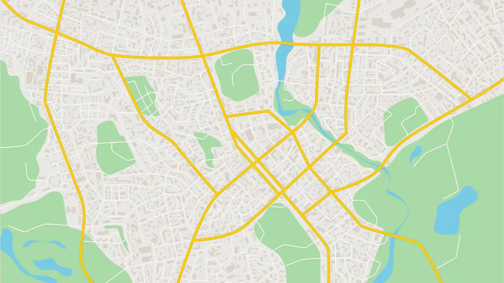
Image annotation is the process of marking and outlining objects and entities in an image and attributing various tags to classify it in a manner readable to machines. Geospatial annotation encompasses qualifying images captured from the aerial mode and those from the satellites into AI & Machine compatible datasets. This leads to a built-in real-time dataset to assess and provide critical actionable data to businesses. Mapping large farms, construction sites, mines, real estate developments, disaster recovery situations & geographical features are a few commonly annotated Geospatial imagery. Geospatial annotation provides an invaluable source of input data for machine learning tools & is becoming increasingly vital in the context of algorithms that allow for efficient access and retrieval of images from large Geospatial datasets.
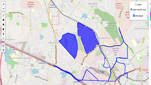
A Point of Interest (POI) is a specific geographic entity such as an office, a garage, a public plaza, a yard, a tourist attraction, a school etc. Points of interest forms the base for most of the data supporting location-based applications. POI Tagging provides a dataset that is a quick, easy and accurate way to support a host of applications like digital mapping, remote surveillance, area-level land zoning, validation of private databases etc. POI Tagging also creates a unique database for governments and other industries with exact geometric coordinates to aid in various developmental projects. POI tagging is a combination of spatial and non-spatial data(capturing images & the collation of attributes of a related asset like name & address) and allows businesses to create dynamic systems that reflect the usage of various services by the people.
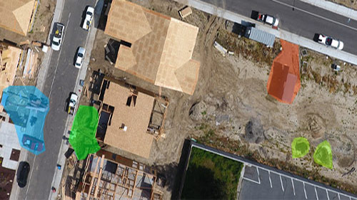
Damage Area Annotation provides organizations with an automatic system for the assessment of damage from high-resolution imagery requiring little or no manual supervision. Numerous natural & human-induced disasters threaten vulnerable areas of the world quite often. Damage Area Annotation deploys Advanced computer vision approaches to manage post-event rescue, reconstruction & insurance plans efficiently. DAA assessment systems rely on optical data, which are processed to detect & assess the level of damage. According to the available data, these approaches either use only post-event images or both pre and post-event images. In the field of auto insurance, images of an auto accident, including the conditions, scene, and repairs needed are extracted & analyzed to provide insights. They also aid and speed up the inspection process, benefiting both insurers and the insured. Damage Area Annotation datasets fed to the AI Algorithms also scrutinize vehicle imagery to help assess damage post accidents.

Footprint maps provide the outline of a building drawn along the exterior walls, with a description of the exact size, shape, and location of its plinth. Buildings have come to be known as the basic ‘unit’ of our civilization & an essential parameter to measure various indicators. Footprint annotation provides the accurate data needed to develop building footprints of the required location by an artificial intelligence algorithm capable enough to identify and extract building footprint data and deliver it in a usable format. The number of buildings within a given perimeter, risk identification from surrounding natural/industrial elements, and complete locational accuracy by verifying a building’s exact location through rooftop geofencing are a few applications powered by Footprint annotation. This ever-growing domain finds application in Insurance, Construction, Real Estate, Navigation, Social & Economic Organisations, Defense, Urban planning, Rural development etc.
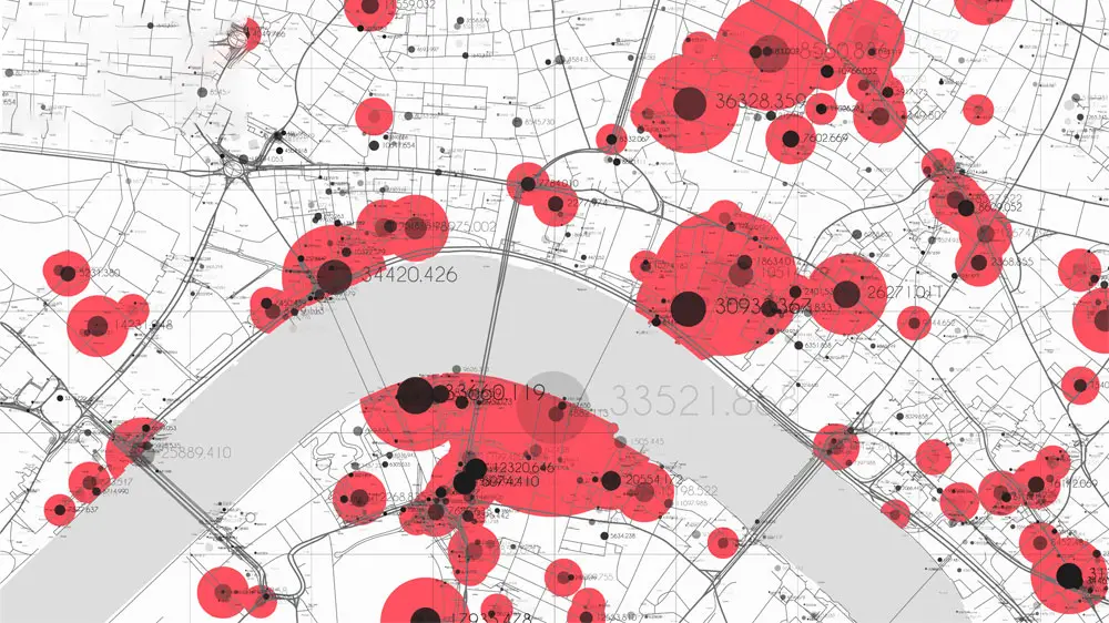
Geospatial annotation can be used to create rich maps by adding information about the features of location such as roads, buildings, and rivers, to a base map.
Geospatial annotation can be used to create data layers that are used in GIS analysis. This allows users to analyze and visualize spatial data to understand patterns and relationships. Spatial relationships may display topography, such as agricultural fields and streams, display land usage patterns such as location of parks, housing complexes etc.

Geospatial annotation can be used to map areas affected by natural disasters, such as earthquakes, hurricanes, tsunamis and floods, in order to aid in rescue and reconstruction efforts.

Geospatial annotation can be used to track the movement of wildlife, monitor changes in land use or land cover, and monitor the health of both terrestrial & marine ecosystems.

Geospatial annotation can be used to create context-rich maps that show the locations of tourist attractions, hotels, and other points of interest, which can be useful for tourists and travel agents.

Geospatial annotation can be used to create maps that show the locations of properties which can be used by realtors and buyers/renters.